
Geophysical Modeling
Geophysical Modeling
Geophysical modeling refers to the process of using various techniques to gather data about the Earth’s subsurface features and properties. The aim of geophysical modelingcan vary depending on the specific goals of a project or study, but some common objectives include:
Geophysical mapping is often used in the search for valuable subsurface resources such as oil, natural gas, minerals, and groundwater
Geophysical mapping can help assess the environmental impact of human activities such as mining, construction, or waste disposal. By characterizing subsurface structures and identifying potential hazards such as contaminated groundwater or unstable geological formations, geophysicists can contribute to environmental management and remediation efforts.
Geophysical techniques are valuable tools for geological mapping, allowing scientists to study the structure, composition, and history of the Earth’s crust. By analyzing seismic data, magnetic anomalies, gravity variations, and electrical resistivity, geologists can create detailed maps of subsurface features such as faults, folds, sedimentary layers, and volcanic structures.
Geophysical mapping plays a crucial role in engineering projects such as building roads, bridges, tunnels, dams, and skyscrapers. By providing information about subsurface conditions and potential geohazards, geophysical surveys help engineers design structures that are safe, stable, and cost-effective.
Geophysical mapping can contribute to the assessment and mitigation of natural hazards such as earthquakes, landslides, and volcanic eruptions. By monitoring seismic activity, subsurface stress patterns, and changes in groundwater levels, geophysicists can identify areas at risk and develop strategies to reduce vulnerability and improve disaster preparedness
Geophysical techniques such as ground-penetrating radar (GPR) and electrical resistivity tomography (ERT) are valuable tools for archaeological surveys. By detecting buried structures, artifacts, and geological anomalies, geophysicists can non-invasively map archaeological sites and plan targeted excavations.
Equipment
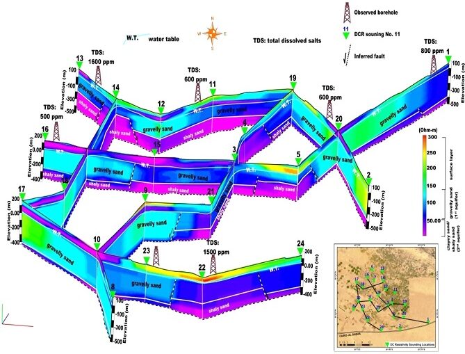
Electrical resistivity imaging measures variations in the electrical conductivity of subsurface materials. Different geological formations exhibit different resistivity values, allowing geophysicists to map subsurface structures such as groundwater aquifers, bedrock fractures, and contaminant plumes.
Integration with 3D Visualization: Electrical resistivity data can be used to create 3D models of subsurface conductivity variations. Visualization software can display these models in three dimensions, providing insights into the spatial distribution of subsurface features and helping to plan geological investigations and resource exploration activities
GPR uses electromagnetic pulses to image subsurface features such as buried objects, archaeological artifacts, and geological layers. GPR is commonly used in archaeological surveys, engineering investigations, and environmental assessments.
Integration with 3D Visualization: GPR data can be processed to create three-dimensional representations of subsurface structures and objects. Visualization software allows users to view GPR data in 3D, facilitating the interpretation of complex subsurface features and aiding in the identification of archaeological sites, buried utilities, and geological anomalies.
.” It is a geophysical method used to determine the shear wave (S-wave) velocity profile of the subsurface. S-wave velocity is a critical parameter for understanding the mechanical properties of soils and rocks, which is essential for various engineering and environmental applications.